March 30, 2012
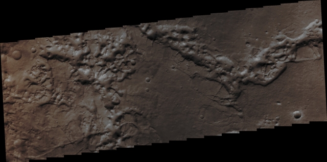
Credits: NASA/JPL/Arizona State University (ASU) - Credits for the additional process. and color.: Dr Paolo C. Fienga/Lunar Explorer Italia/IPF
|
Margaritifer Terra (located in the Sinus Margaritifer Quadrangle) is an ancient, heavily cratered Region of Mars which is centered just South of the Martian Equator, at 4,9° South Lat. and 25° West Long.; Margaritifer Terra covers approx. 2600 Km at its widest extent and also reveals the existence, within it, of Chaos Terrain, Outflow Channels and Alluvial Plains: needless to say, all these Surface Features are not only indicative of an ancient, and yet very vast and branched, Fluvial Activity, but also of the verification of a massive Flooding, which must have occurred in the Region probably over a Billion Years ago. Wind Erosion Patterns are also visible in several areas of Margaritifer Terra, as well as a number of Valley Networks (whose Density is actually the highest on the whole Red Planet). Talking about ancient Riverbeds, the Ares Vallis is another notable Surface Feature of Margaritifer Terra, since the Flood and Flow Patterns, over there, appear more evident than anywhere else on Mars. It has to be remembered that Ares Vallis was the Landing Site of two probes: the Soviet Space Agency's - Mars 6 Lander (which successfully lifted off on August 5, 1973, into an Intermediate Earth Orbit, on a Proton SL-12/D-1-e booster, and then launched into a Mars Transfer Trajectory. The total fueled launch mass of both the Lander and Bus was 3260 kg. The Soviet Spacecraft reached Mars on March 12, 1974. The Descent Module separated from the Bus at a distance of approx. 48.000 Km from Mars and, while the Bus continued on into an Heliocentric Orbit after passing within only 1600 Km of Mars, the Descent Module entered the Atmosphere of the Red Planet at 09:05:53 UT and at a speed of 5,6 Km/sec. The parachute opened at 09:08:32 UT after the Module had slowed its speed to 600 mt/sec by way of Aerobraking. During this time, the Spacecraft collected many data and transmitted it directly to the Bus, for immediate relay to Earth. Contact with the Descent Module was lost at 09:11:05 UT, when the Spacecraft was in "direct proximity to the surface", probably either when the retrorockets (mis)fired or when it hit the Surface at an estimated speed of about 61 mt/sec. Mars 6 landed at 23‹ 54Œ South Lat. and 19‹25Œ West Long., in the Margaritifer Terra Region of Mars. The landed mass was 635 Kg. The Descent Module transmitted, for 224 seconds before the signal ceased, the first Data ever returned from the Atmosphere of Mars. Much of the other Data, however, was lost or unreadable, probably because of a flaw in a computer chip which led to the degradation of the whole transmission system during the Spacecraft's journey to Mars), and the NASA's - Mars Pathfinder Lander. Furthermore, Holden and Eberswalde Craters, both located within Margaritifer Terra, are thought to be the dry remnants of two extremely ancient Martian Lakes; this hypothesis is based on the fact that both Craters contain large Deltas as well as the mineral known as Iron-Magnesium Smectites (which need Water to form). Picture Data: Orbit Number: 43406; Latitude: 8,665° South and Longitude: 337,077° East; Instrument: VIS; Captured: September, 27th, 2011; Mars Local Time (M.L.T.): 07:04 (Early Morning Hours) This frame has been colorized in Absolute Natural Colors (such as the colors that a human eye would actually perceive if someone were onboard the NASA - Mars Odyssey Orbiter and then looked down towards the Surface of Mars), by using an original technique created - and, in time, dramatically improved - by the Lunar Explorer Italia Team. |
News visualized: 682 times

