June 6, 2012
Credits: NASA/JPL/University of Arizona - Credits for the additional process. and color.: Dr Paolo C. Fienga/Lunar Explorer Italia/IPF
|
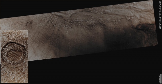
Dao Vallis is an Outflow Channel that begins on the South/Eastern Flank of the broad low-relief Volcano Hadriaca Patera and then it extends in a South-Westwardly direction across the Southern Highlands for approximately 1000 Km, to finally end near the Hellas Basin. Outflow Channels are generally thought to be the result of a catastrophic release of enormous amounts of Ground-Water that create Floods powerful enough to scour the Surface of a given Celestial Body (Mars, here, for exdemple) over periods going from just a few days, up to several months. Today's APOD shows portion of the Southern Wall of Dao Vallis, just upstream of its Confluence with Niger Vallis. The Gullies that flow into Dao Vallis begin just below the top of the Valley Wall and erode through the Upper Rock Layers. Gully Deposits appear to overlap the Material that fills the Valley Floor. Such a Valley Fill Material was, very likely, Ice-rich and it must have flowed down the Wall (or the Valley) in a way that could have been similar to the slow moving Glacial Material on Earth. Located beyond the Gullies and on the Valley Floor, there is an intriguing Crater-like Surface Feature which is surrounded by Concentric Fractures (watch the EDM Feature in the inset). These Fractures would allow Ice to Sublimate into the Martian Atmosphere from the Subsurface Materials, thus causing a progressive Collapse (---> sinking) of the Crater Walls and resulting in the formation of the interior Hummocky Terrain (note: the Hummocky Terrain is a type of Terrain located on a Planetary Surface which consists of irregular rounded mounds distributed in a chaotic pattern. The inner part of the Ejecta Blanket of a relatively young Impact Crater, for instance, is, usually, a good example of Hummocky Terrain). Fine-grained Sediments are trapped by the Hummocky Terrain and are reworked by Local Winds forming Dunes on the central portion of the Crater Floor. Mars Local Time: 14:32 (Early Afternoon) This frame has been colorized in Absolute Natural Colors (such as the colors that a human eye would actually perceive if someone were onboard the NASA - Mars Reconnaissance Orbiter and then looked down, towards the Surface of Mars), by using an original technique created - and, in time, dramatically improved - by the Lunar Explorer Italia Team.
|
News visualized: 707 times

